Property Record
100 Jerry Dowd Dr, Carrollton, GA 30117

NEARBY LISTINGS FOR SALE OR LEASE
Property Detail
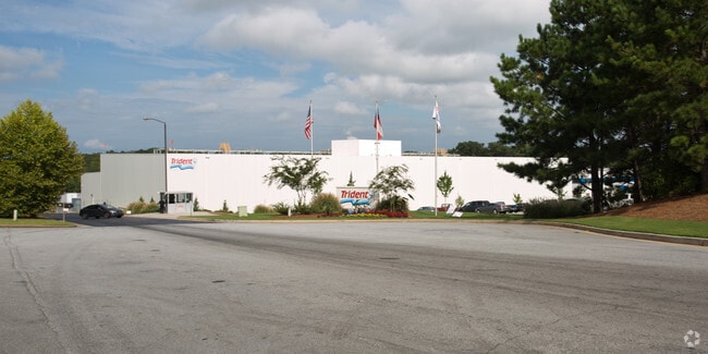
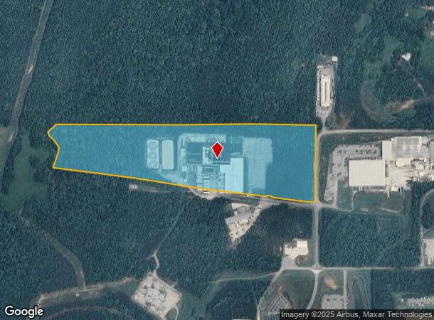
100 Jerry Dowd Dr
C02-0430187
Trident Carrollton Llc
Shipyard
IND BLDG/31AC PERFORMANCE WAY C1/CTY74
X
Carroll
13045C0251D
Georgia
0
31 AC
2025
W Carroll County
910503
Atlanta
162,219 SF
Atlanta-Sandy Springs-Roswell, GA
DEMOGRAPHICS near 100 Jerry Dowd Dr
1 Mile
3 Mile
5 Mile
2024 Total Population
419
17,381
40,640
2029 Population
468
19,294
45,145
Pop Growth 2024-2029
+ 11.69%
+ 11.01%
+ 11.09%
Average Age
35
33
35
2024 Total Households
152
5,831
14,681
HH Growth 2024-2029
+ 11.84%
+ 11.30%
+ 11.30%
Median Household Inc
$45,208
$41,539
$46,490
Avg Household Size
2.70
2.60
2.50
2024 Avg HH Vehicles
2.00
2.00
2.00
Median Home Value
$194,642
$170,302
$205,921
Median Year Built
1991
1987
1985
Nearby Places
Map Layers
Map Styles
 Street
 Aerial
- Restaurants
- Banks
- Shops
- Fitness
- Groceries
Nearby Properties
Address
Land Use
TOTAL SIZE
Lot Size
Zoning
Address
Land Use
TOTAL SIZE
Lot Size
Zoning
53.04 AC
OI
Address
Land Use
TOTAL SIZE
Lot Size
Zoning
932,068 SF
150.44 AC
I
Address
Land Use
TOTAL SIZE
Lot Size
Zoning
452,050 SF
34 AC
M2
Address
Land Use
TOTAL SIZE
Lot Size
Zoning
820,922 SF
84.15 AC
M2
Address
Land Use
TOTAL SIZE
Lot Size
Zoning
39,268 SF
12.05 AC
RM-10
Address
Land Use
TOTAL SIZE
Lot Size
Zoning
44,708 SF
9.92 AC
RESIDENTIA
Address
Land Use
TOTAL SIZE
Lot Size
Zoning
162,506 SF
23.32 AC
M2
Address
Land Use
TOTAL SIZE
Lot Size
Zoning
13,585 SF
14.93 AC
R3
Address
Land Use
TOTAL SIZE
Lot Size
Zoning
12,752 SF
15.63 AC
R3
Address
Land Use
TOTAL SIZE
Lot Size
Zoning
23,801 SF
14.78 AC
PD/R-M
Address
Land Use
TOTAL SIZE
Lot Size
Zoning
13,185 SF
26.29 AC
R4
Address
Land Use
TOTAL SIZE
Lot Size
Zoning
17,102 SF
33.57 AC
R3
Address
Land Use
TOTAL SIZE
Lot Size
Zoning
17,000 SF
13.52 AC
R3
Address
Land Use
TOTAL SIZE
Lot Size
Zoning
69,336 SF
25.63 AC
M1
Address
Land Use
TOTAL SIZE
Lot Size
Zoning
170,850 SF
10.97 AC
M2
Address
Land Use
TOTAL SIZE
Lot Size
Zoning
341,714 SF
44.49 AC
M2
Address
Land Use
TOTAL SIZE
Lot Size
Zoning
101,000 SF
15 AC
RESIDENTIA
Address
Land Use
TOTAL SIZE
Lot Size
Zoning
90,800 SF
10.89 AC
C2
Address
Land Use
TOTAL SIZE
Lot Size
Zoning
128,000 SF
0.74 AC
M2
Address
Land Use
TOTAL SIZE
Lot Size
Zoning
117,105 SF
8.74 AC
M2
Address
Land Use
TOTAL SIZE
Lot Size
Zoning
9,891 SF
11.54 AC
R3
Address
Land Use
TOTAL SIZE
Lot Size
Zoning
109,300 SF
127 AC
I
Address
Land Use
TOTAL SIZE
Lot Size
Zoning
15 AC
R20
Address
Land Use
TOTAL SIZE
Lot Size
Zoning
39,500 SF
15.36 AC
OI
Address
Land Use
TOTAL SIZE
Lot Size
Zoning
16,743 SF
10.92 AC
R2
Address
Land Use
TOTAL SIZE
Lot Size
Zoning
64,000 SF
0.24 AC
M2
Address
Land Use
TOTAL SIZE
Lot Size
Zoning
41,705 SF
3.77 AC
M1
Address
Land Use
TOTAL SIZE
Lot Size
Zoning
5,000 SF
7.75 AC
OI
Address
Land Use
TOTAL SIZE
Lot Size
Zoning
7,208 SF
9.87 AC
R3
The World's #1 Commercial Real Estate Marketplace
Connect with us
© 2025 CoStar Group
The information above has been obtained from sources believed reliable. While we do not doubt its accuracy we have not verified it and make no guarantee, warranty or representation about it. It is your responsibility to independently confirm its accuracy and completeness. Any projections, opinions, assumptions, or estimates used are for example only and do not represent the current or future performance of the property. The value of this transaction to you depends on tax and other factors which should be evaluated by your tax, financial, and legal advisors. You and your advisors should conduct a careful, independent investigation of the property to determine to your satisfaction the suitability of the property for your needs.